Committee: Facilities, Parks, and Recreation
Cost: $75,000
Location: Danehy Park
Short Description: This proposal will install new signs and maps at Danehy Park. Existing signs are broken, outdated, or missing making it difficult to navigate the 50-acre park. New signs will make Danehy inviting and easy to navigate for all visitors.
Long Description:
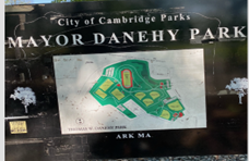
It is difficult to navigate Danehy Park. The park covers over 50 acres with four soccer fields, a track, three basketball courts, five baseball/softball fields, three playgrounds, a dog park, and more. But good luck finding these things the first time you visit as there are no maps posted at the entrances or parking lots. The few existing signs are in poor condition. While some of the fields are labeled, others are not, leaving athletes to wander around trying to find their game. The DePasquale Universal Design Playground, which opened in 2021, is not included on the one posted map.
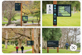
This proposal will make Danehy Park easier to navigate by upgrading and adding new signage. Maps will be posted at park entrances and major branching points. Signs will provide directions to key locations such as bathrooms and ball fields and display the rules, regulations, and expectations of park use. This proposal recommends including features such as internationally recognized symbols, bright colors, tactile paving on sidewalks, solar-powered interactive maps, and 3D maps. Having a new wayfinding system at Danehy Park will improve an already beautiful park. People of all ages and abilities deserve the opportunity to easily explore this well-used and loved center of community life.


